
Post by Dr. Paulo Rui Anciaes
This is the fourth and last post about the Street Mobility team trip to South America to explore issues of community severance and the links between urban transport and health. As in the case of Bogotá and São Paulo, talking about urban transport in Santiago de Chile is talking about social inequalities. Despite Chile’s continued economic growth, Santiago remains a city with large socio-economic disparities, which are compounded by the fragmentation of the city in physically separated neighbourhoods.
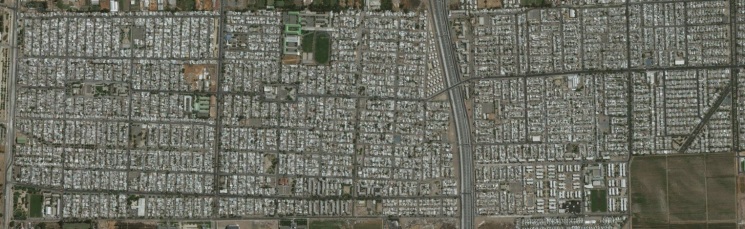
Most of this fragmentation is caused by transport infrastructure. The image below shows how the Acesso Sur motorway separates two neighbourhoods in the comunas of La Pintana and Puente Alto in the southern limits of Santiago. The neighbourhood in the left is also divided on the west side by the Avenida Santa Rosa, a road with an environment so hostile that is often likened to an airport runway.
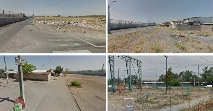
The construction of the Metrotren Rancagua, a railway line between Santiago and the city of Rancagua, has contributed to the increase of severance of many places in South Santiago. For example, the comuna of Lo Espejo is cut in half by the Metroten Rancagua, with some neighbourhoods, like the one below, being surrounded by road and rail infrastructure.

These barriers have a negative impact on the wellbeing of local residents, as they decrease their walking mobility and access to nearby neighbourhoods, not to mention noise and vibration. Because of this, the residents have staged various protests against the contruction of the Metrotren Rancagua.

Protesting against the Metrotren Rancagua (photo: Francisco Águila, Emol.com)
But large transport infrastructure are more than barriers to mobility. They anihilate everything in its surroundings, which become inacessible, polluted, unpleasant, and dangerous areas repelling people and businesses. Jane Jacobs calls these areas “border vacuums” that suck life out of the city.
Perhaps is no surprise that some of the neighbourhoods in the comunas mentioned above are among the poorest in Chile and are at the bottom of the national ranking of quality of life. And that the more affluent households in Santiago live in areas with much better environmental quality, such as Providencia, Las Condes, and Vitacura, far from noisy motorways and near large, high-quality, green areas.

The problems of walking and cycling are compounded by problems in using public transport. The Transantiago (Santiago’s public transport system) was never too far away in all the conversations we had with our local colleagues. This was also the topic of an article in The Economist last year, aptly titled “Going Nowhere”, and describing how bus journeys have slowed down 8% since 2012, and how “passengers sometimes wait ages at stops scrawled with graffiti with no inkling of when the next bus will arrive”. A report on personal security in public transport also found that 85% of public transport in Santiago users have been harassed when travelling by bus or metro or walking to stops and stations.
The transport (and economic, and health) inequalities in Santiago are rooted in the urban policies of the 1980s, which resulted in poorer people living in distant suburbs, with limited public transport access, and a lack of good quality public spaces. In a seminar on transport equality, Victor Barrueto, from the Association of Urban Surface Transport Operators said that “se ha dejado a la gente con menos recursos económicos en el fin del mundo, lo que trae grandes dificultades para trasladarse a las zonas de trabajo y son ellos los que ocupan el transporte público mayoritariamente.” [“less affluent households were stuck at the back of beyond, where they cannot access the places where jobs are – despite the fact that they are the ones that need public transport the most”] (in Cambiarnos (2014) Hacia Un Transporte Metropolitano Justo).
But even the central parts of Santiago have problems. The Central Motorway crosses the city centre from north to south and the North Costanera, a motorway which connects rich areas in East Santiago to the airport and then to the beaches, crosses the centre from west to east, although it goes through a tunnel in some parts. But just some blocks further down, there is the Alameda, the main avenue in Santiago, which, despite the trees, is a noisy, chaotic road which, by being so central, is difficult to for pedestrian to avoid.

Even in quiet neighbourhoods there is too much road space given to cars, and little left to share between cyclists, pedestrians, and trees.

We were lucky to visit Santiago in 2017, as several radical policies are currently being implemented (or designed) to address some of the problems described above. There is an ongoing consultation process to radically redesign the Alameda, reallocating more space to pedestrians and cyclists, improving access to public transport, and regenerating the existing green areas. Another big plan is the Mapocho 42k, a cycling route along the River Mapocho, crossing the whole of Santiago and linking several existing and proposed green areas. The Ruta de la Infancia will be a 17km cycling route linking two major children’s attractions, and then linking with the Mapocho 42k.
The Santiago City Centre Mobility Plan also has pedestrians, cyclists, and public transport users as priorities. Alexis Arevalo from the Urban Mobility team of Santiago municipality and Tomas Echiburu, Councillor for the Providencia comuna, showed us some of the interventions that helped Santiago to win the 2017 International Sustainable Transport Award of the Institute for Transportation and Development Policy. The Paseo Ahumada and Paseo Huerfanos, the two main pedestrianised streets in Santiago, were given a new life (first photo below) and the Paseo Bandera reopened one month after our trip, as a very colourful street. In nearby Calle Compania, the pedestrian pavements were widened from 80cm to 250cm. Bus stops were also redesigned (second photo below).


Public places were also improved, both the main ones at the heart of the city and smaller ones in other neighbourhoods.


There were also innovative ideas to create new public spaces, such as Plazas de Bolsillo (‘pocket squares’) (top picture below), and other small areas created from reclaiming space that was previously used by cars, either moving or parked.


At the national level, a new law on Convivencia Vial (Road sharing) will reduce traffic speed to 50km/h in urban areas and give the municipalities more powers to reallocate road space to pedestrians and to designate 20, 30, and 40km/hr zones. That will not reduce the separation caused by “absolute” barriers such as the one I showed in the beginning. But it will reduce the collision risk and improve the pedestrian environment in other roads.
Improving the accessibility of residents in the poorer southern suburbs remains a challenge. One project that could benefit those suburbs is the Anillo Interior, a ring road using the space historically used by a railway, and which would be used as a bus corridor. Much has been said and written about this during the last 20 years, but the project is yet to be completed.
Overall, providing accessibility and environmental quality for all is also a project yet to be completed in Santiago, but the ongoing changes are encouraging.
